Maui's and Hector's dolphins regulations
South Coast South Island - Trawl Restriction
Trawl gear is restricted offshore to two nautical miles between Slope Point in the Catlins and Sand Hill Point east of Fiordland – only trawl nets with defined low headline heights may be used:
- the net has been manufactured or modified with the intention of having a net opening with a vertical height of no more than 1 m; and
- the net is fitted with a device (for example, a spreader bar, rope, or wire) that is no more than 1 m long on the wing-end to constrain the wing-end height to below 1 m; and
- the net has buoyancy on the headline that does not exceed 60 kg; and
- the net is not modified in any way or manner that would allow the vertical height of the net opening to exceed 1 metre.
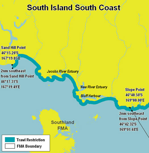
This map is intended to be used as a guide only, in conjunction with other data sources and methods, and should only be used for the purpose for which it was developed. Although the information on this map has been prepared with care and in good faith, no guarantee is given that the information is complete, accurate or up-to-date. All coordinates are provided in WGS84 decimal minutes.
This information is only a guide to new trawl restriction in the Southland Fishery Management Area. You must check for other trawl restrictions and prohibitions in the area where you plan to fish – before you go fishing. Fisheries regulations are available at most bookshops.
See Also
South Coast South Island - Trawl map - Low Resolution (Jpeg 90kb)
South Coast South Island - Trawl map - High Resolution (Jpeg 146kb)
Please save Jpeg maps before printing
 South Coast South Island - Trawl map (PDF 169kb)